


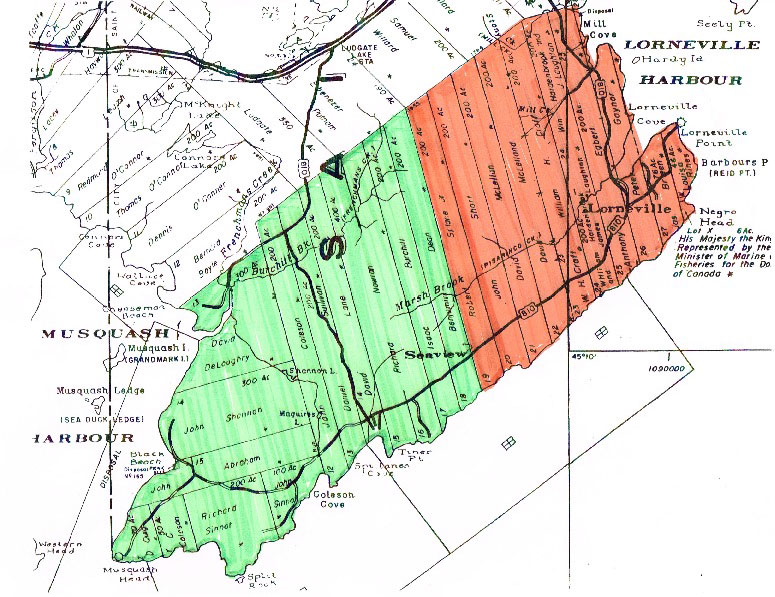
The Settlement of Lorneville
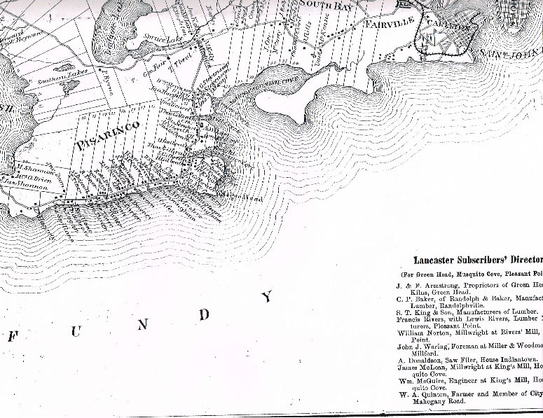
Lorneville is a coastal community on the Bay of Fundy and since 1967 is the most western part of the City of Saint John N.B. It is located on a very rugged part of the Fundy shore between Manawagonish (or Mahogany) Cove and Musquash Harbour and has been home for generations of people for over 200 years. Extending inland from the shore about 3.5 kilometers, Lorneville is graced with the natural beauty of rugged forest land, and several streams, beaches, salt marshlands, and wetland areas. Lorneville has been long regarded as one of many picturesque fishing communities along this part of the Bay of Fundy.
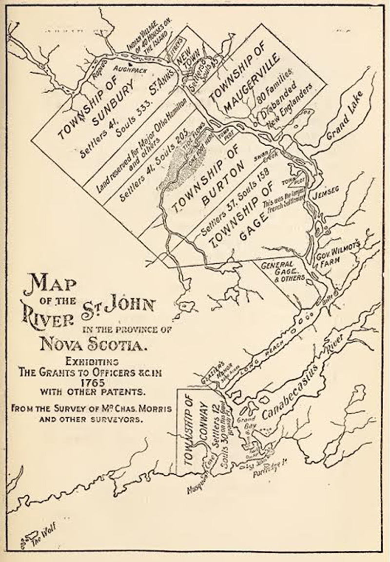
Lorneville was once part of the Township of Conway, Sunbury County, in the British Colony of Nova Scotia from about 1765 until the arrival of the Loyalists in 1783. Conway was established c 1765 along with a number of other Townships along the Saint John River to facilitate Crown Grants of land to British Armed forces veterans. It was located on the west bank at the mouth of the Saint John River and Harbour, and extended up river as far as Nerepis, and westward along the Bay of Fundy Shore to include all of South Musquash. Prior to the arrival of the Loyalists in 1783, the population of the Township of Conway was reported at only 12 land holding families and 30 persons. It is unlikely that any resided at present day Lorneville.
Settlement of the Lorneville area started with the arrival of the Loyalists. All of the land along the Fundy shore from Musquash Harbour to Manawagonish Cove was divided into 26 parcels of roughly 200 acres and was granted to a group of Loyalists via a general Crown Grant known as the “Egbert Grant”. This grant was issued on September 22, 1784 when New Brunswick was still part of the British Colony of Nova Scotia . The grant was named after Anthony Egbert, a carpenter from Staten Island, New York , who happened to be the first named grantee on the list.
Most of the Loyalist grantees did not settle their grants or maintain title to their lands at Lorneville, finding the terrain too rough with better living situations available elsewhere. A few Loyalist owners, including Egbert, Peter Gaynor, and William Hardenbrook/James Lawton or their tenants and offspring, did start to settle the area beside the main tidal harbour at Lorneville. This was “the neck of land” jutting eastward toward Saint John that became known as ‘The Point”. Flat salt water marshland at the upper end afforded opportunity for cultivation and the beaches above the high water mark on this peninsula good shelter and landing areas for coasting and fishing vessels. This cove was the only sheltered inlet between Musquash Harbour and Saint John, so it was an important geographical feature in the early days of the Colony. For the communities at Musquash it provided a transportation link to Saint John by both water and land.
The earliest public road was built from Musquash Harbour and terminated at the Lorneville Creek where a public landing had been reserved on the beach area below the salt marsh. This was located on the Crown Grant to Peter Gaynor (Egbert Grant), a Loyalist immigrant and block maker from Rhode Island3, whose family maintained an interest in this property until 1834. Communication to Saint John was by water from this point.
West of the Gaynor property was Anthony Egbert’s 200 acre Crown Grant. It included part of the salt marshlands at the head of both of Lorneville Creek and Mill Creek and it changed hands several times since granted to Egbert in 1785. By 1817, the Egbert property and the 200 acre Loyalist parcel next to that had been owned by Hardenbrook/Lawton it had come into the possession of William Henry Craft Sr. of Saint John, and his father-in-law, John McKenzie Sr., of York Co., N.B.
Craft was the son of Loyalist immigrants John Thorn Craft and Susannah Wetmore of New York,4 and he and the McKenzie family established an extensive farm on the 400 acre property. A grist mill was established on the Mill Stream, giving it its’ name. In 1822 William Craft Sr. applied to the Governor and Council of New Brunswick for a Crown Grant of the vacant 200 acre parcel along the western boundary of the farm5. When it was granted to him in 1832, the Craft property totaled 600 acres.
By 1820 the Loyalist settlement on the “neck of land” along Lorneville Creek included at least two other families besides the Gaynor’s, Crafts’, and the families of John McKenzie Sr. and John McKenzie Jr. – William Ryons (Rynes) and Thomas McFadin (McFadden). An early nautical map (Lockwood, 1818) of the coastal area around the entrance to Saint John Harbour referred to this area as “Viasrinkum”. The spelling evolved over time to Pararinko, Pisicrino, etc. until finally Pisarinco. The origins of the name are not clear, but it is likely of Maliseet origin, and may mean fishing village or area.
Loyalists founded and established many settlement areas in southern New Brunswick including those at Saint John, Musquash, and along the neck of land at Visarinkum, but it was Irish migration to New Brunswick from 1815-1825 that swelled the population and led to further settlement in the area. Irish settlers primarily from the south of Ireland – Co Cork, Wexford, Kilkenny, Tipperary – began to apply for (and receive) grants of lands in the “Egbert” tract, including parcels that had been abandoned by the original Loyalist owners. Settlement progressed from Musquash Harbour eastward along the Bay of Fundy coast. Family names of these early settlers included Shannon (John), Abraham (John), DeLoughry (David), Sinnott (John & Richard), Coleson (John Sr. & Samuel), Lane (David), Sullivan (Daniel), Splane (Robert &Michael), Dean (Benjamin Sr.), and Burchill (Isaac). Their religious affiliation was primarily Roman Catholic and Church of Ireland. The settlement area stretched from Musquash Harbour to the Benjamin Dean Grant (near the eventual location of Seaview School) and it became known as “Irishtown”. This place name is referenced in property deeds at least as early as 1840 and appears in early Directories for New Brunswick Counties (Hutchinsons Directory & Lovells Directory) in the 1860’s and 1870’s.
By 1825 most of the vacant lands laid out in the Egbert Grant were applied for, assigned, or settled in some fashion. Only one large (200 acre) parcel remained vacant and unapplied for in Irishtown (with a couple of smaller parcels near Black Beach) and there were only three more two hundred acre lots available east of Irishtown at Pisarinco along the rugged highland shore of the Bay of Fundy (the “Ridge”).
The rules for crown land grants in New Brunswick were modified circa 1827.No longer were “free” Crown Grants awarded through the Colonial Administration but vacant or previously unapplied for tracts of land could be obtained at a set fee per acre. Applicants could also pay over time. By 1832 all the remaining large tracts of vacant lands in the Ebert tract area had been applied for and assigned to Richard Nowlan (Irishtown) and John Short and David McClellan (Pisarinco). Properties had also begun to change hands and to be subdivided as immigration to the Province continued and population increased. Land was in demand to meet the needs and expectations of newcomers.
Several developments occurred in the late 1820’s and early 1830’s that would have ramifications for the future development of the settlements being established at Pisarinco and Irishtown. First, Richard Nowlan, a native of Ireland and painter from Saint John, and his wife, the former Anna Bean, acquired 200 acres on Irishtown Cove in 1827 from David Lane8. Nowlan would go on to purchase two other parcels of 200 acres from early Irishtown settlers, John Abraham and Isaac Burchill, plus he successfully applied to the Province in 1832 for two more 200 acre parcels. The latter action precipitated a bitter dispute over ownership of one of the pieces of land which had been previously applied for by Irish natives Robert & Elizabeth Splane, cleared and settled by the Splanes and their in-laws, Michael & Mary Splane, and John and Angeline Peters. In all, Nowlan would come to possess 1000 acres in Irishtown and he then began to re-sell to newer immigrants to the area, primarily families and individuals from the south of Ireland.
The second significant development that occurred during the late 1820’s early 1830’s was that a number of individuals and families from the Kilkeel district of County Down Northern Ireland migrated to New Brunswick and landed at Saint John. Some of these immigrants were older, with large established families, and some were younger and just starting out. Kilkeel is a coastal community in the southern part of County Down facing eastward on the Irish Sea, with Carlingford Lough to the south and the Mourne Mountains directly behind on the west. Seafaring, farming, and fishing were principle occupations in Kilkeel and Saint John was a good fit for these newcomers. They began to seek opportunities to acquire land for farming and become more permanently settled in the area.
Concurrent with the continuing migration of emigrants from Ireland to New Brunswick, events began to transpire in the early Loyalist settlement at Pisarinco to make land available for sale. Peter Gaynor’s grandson, John Beach Gaynor, sold the family’s holdings there on the Point Road in 1833 to Irish immigrants James and Maria (Magee) McCoach for 50 pounds9. William H. Craft’s father-in-law, John McKenzie Sr. died in 1834 and the next year Craft sold the families’ 600 acre farm to prominent Saint John merchant, John Robertson10. Mr. Robertson was appointed Mayor of the City of Saint John in 1836, and later served in the New Brunswick Colonial Provincial Government. Still later he was an M.P. and Senator of Canada after Confederation in 1867. Robertson probably had the lands at Pisarinco lumbered and further cleared. In 1838 he had the property reconfigured into six smaller parcels suitable for farming, but with water access and greater utility and sale value. In addition to the former Craft farm property, several other properties in Pisarinco also went for sale circa 1838-1840.
The first emigrant from Kilkeel to acquire land in Pisarinco was William Dalzell. In late 1838 he and wife Margaret (Baird) purchased 150 acres on the Point Road from Moses O’Bryan. 11Then in 1839, Samuel Ferguson Sr. and wife Nancy (Knox) acquired 100 acres in Pisarinco near the present Seaview Cemetery from John & Mary Short.12 On January 1, 1840 the six parcels of land carved from the 600 acre former Craft farm were sold by John Robertson to six more immigrants from Kilkeel:
- Lot A – “first of the settlement” – John Stevenson (Stinson) and wife Jane (Perry)
- Lot B – “north bank of Mill Creek” – Henry Baird Sr. (& wife ?)
- Lot C – “ south bank of Mill Creek – William Perry Sr. and wife Jane (Moore)
- Lot D – “ north bank of Marsh Creek” – Thomas Galbraith & wife Helen (Perry)
- Lot E – “109 ac by Lorneville Cemetery” – John McKnight & wife Agnes or Nancy (Perry)
- Lot F – “ south bank of Marsh Creek” – James Galbraith Sr. & wife Isabella (Ewart)
Later in 1840 Kilkeel area immigrants Samuel Cunningham Sr. and wife Mary acquired 400 acres from David & Mary McClellan of Portland Parish (North End Saint John). This was just west of the former Craft farm (and the lot purchased by John & Nancy McKnight). Samuel Cunningham Sr. immediately deeded 100 acres to Hugh McCavour Sr. and wife Jane (Floyd). Within two years, all of Pisarinco” from the beginning of the settlement to Seaview Cemetery (with the exception of a couple of properties on “The Point) was owned by ten immigrant families from the town of Kilkeel and nearby Derryogue, County Down Northern Ireland. James and Maria McCoach owned two 50 acre parcels, one on either side of the Lorneville Creek, and a 46 acre lot at Negro Head was probably occupied by the Rynes family. It was later granted by the Crown to Louisa Rynes (1848) and she the sold it to a schoolteacher from Nova Scotia, John Lahey, in 1849.
Other Kilkeel area families drawn to settle at Pisarinco include:
- Robert McKee Sr. (Ella Austin); (he died 1836; she married Sam Cunningham Sr. 1841)
- William Knox (Eliza Jane McLaren); (1841)
- Thomas Byers (Elizabeth Wallace); (1852)
- Samuel Reid (Jane Galbraith) (1851) & James Reid (Mary Ferguson); (1851)
- Alexander McAllister Sr. (Mary Reid); (1851)
- Henry “at the Shore” Galbraith (Agnes “Nancy” McMaster) (1847)
- “Big” Henry Galbraith ( Catherine McCavour) (1862)
- James Ewart Sr. (Mary Jane Moore) (1850)
- James McMaster Sr. (Margaret McCavour) (1856)
- Charles McCavour (Frances McKnight) (1862)
The settlers from County Down were descendants of the 17th Century Ulster plantation of Northern Ireland with Scots and English settlers. They were mainly Presbyterian or Wesleyan Methodist in religious affiliation, whereas their neighbours in Irishtown were mainly Church of Ireland and Roman Catholic.
The foundations of the two farming and fishing communities of Pisarinco and Irishtown were firmly established in the 1840’s and 1850’s. They would continue to develop and grow rapidly with chain migration of family members, friends, and relatives from home communities in Ireland and elsewhere. The Irish famine years of 1844-1848 produced a heavy influx of Irish immigrants to New Brunswick communities and Pisarinco and Irishtown were no exceptions in receiving and helping settle the newcomers.
Families settling in Irishtown included:
- • Daniel & John (Mary) Daly, (1833)
- • John Tyner Sr. and family from County Cork (1839)
- • Robert Splane and Sarah (Farr), from County Tipperary (1826 Pisarinco;1839 Irishtown)
- • Michael Driscoll Sr. and wife Ellen (Donovan) also from Co Cork, (1844)
- • Richard Tyner and wife Martha (Clarke) (Co Cork) 1853
- – son-in law Richard Evans (Mary) & son-in law William Wolfe (Avisia)
- • Samuel Maguire Sr. (Jane Tyner), (1856) his brother Nathaniel Maguire (Mary Ann Driscoll) (1868),
- • James Bryan & Mary Collins from Co. Cork. (1860)
- • Four more Dean emigrants from Ireland and probable relatives of Benjamin (Mary) Dean
- – Thomas Dean (Susan Clarke); (1858)
- – Robert S. Dean (Mary Ann Dean); (1861)
- – Benjamin Dean (Mary Ann Splane); (1855)
- – John Dean (Rebecca Brien) (1858)
- • John (Jane Brophy) Quigg and his brother Henry (Mary) Quigg (1836)
- • Matthew O’Brien (Mary Ann Shannon) (1842)
- • Nathaniel Young (Elizabeth Sinnott) (1866)
- • John Gillingham (from London England) (Mary A. Splane) (1842)
- • Thomas LeSueur (from England) (Angeline Splane) (1842)
- • Joseph Logan (Elizabeth Splane) (1856)
- • Samuel Burchill (Mary Haggerty) County Cork (1873)
Other Kilkeel area families drawn to settle at Pisarinco include:
- • Robert McKee Sr. (Ella Austin); (he died 1836; she married Sam Cunningham Sr. 1841)
- • William Knox (Eliza Jane McLaren); (1841)
- • Thomas Byers (Elizabeth Wallace); (1852)
- • Samuel Reid (Jane Galbraith) (1851) & James Reid (Mary Ferguson); (1851)
- • Alexander McAllister Sr. (Mary Reid); (1851)
- • Henry “at the Shore” Galbraith (Agnes “Nancy” McMaster) (1847)
- • “Big” Henry Galbraith ( Catherine McCavour) (1862)
- • James Ewart Sr. (Mary Jane Moore) (1850)
- • James McMaster Sr. (Margaret McCavour) (1856)
- • Charles McCavour (Frances McKnight) (1862)
Two Wilson brothers from the Portstewart and/or Coleraine area of County Londonderry Northern Ireland landed in Saint John about 1850. William Wilson purchased 50 acres at Pisarinco in 1850 from James and Maria McCoach, This land was located between Lorneville Creek and Mill Creek. William Wilson Sr. (Maria Craig) then divided this property and sold his brother John Wilson Sr. (Roseanna) the northern half on Mill Creek. They settled there in Pisarinco with their families.
James and Maria McCoach also sold the remaining 50 acre parcel they owned on Point Road in 1850 to his brother, Francis McCoach. James and Maria moved to Saint John and in 1853 they took their family and sailed to Australia. In 1859 Francis McCoach married Margaret (McMaster) McIntosh, widow of Kilkeel native John McIntosh. Margaret was the sister of James McMaster Sr. and Agnes Galbraith (Henry at the Shore Galbraith) who also resided at Pisarinco.
The Wilson families from County Londonderry Northern Ireland attracted friends John MacAfee (Jennie Anderson) of Colonsay Scotland, to settle at Pisarinco. Another Scottish immigrant, James Alston Sr. of Edinburgh Scotland, married Nancy Baird and they settled on a part of the Baird property at Pisarinco. Alston later married Alexander McAllister Senior’s widow Mary (Reid).
By 1850 all of Pisarinco from the beginning of the settlement past Seaview Cemetery to the 100 acre property of Dublin Ireland native James Downey (Margaret Morrow) was settled by immigrants from Northern Ireland. The only exception was the 46 acre lot at Negro Head and the end of the Rose Point peninsula owned by the Lahey family from Nova Scotia. The last property in Pisarinco beyond James and Margaret Downey was 100 acres owned by a schoolteacher from England, Thomas Elliott Carter. Carter had married Samuel Cunningham Sr.’s daughter, Ann, in 1840. The next property belonged to Benjamin Dean of the settlement of Irishtown.
The Evans’ families of West Beach (Black River) Saint John County originated from Aughadown, Co. Cork Ireland (Richard Evans Sr. & Mary Shannon) and had family connections to the Cunningham’s in Pisarinco. Two of Richard and Mary’s grandsons – Walter Evans Sr. (Martha MacAfee) and schoolteacher Robert Evans Jr. (Lizzie Reed) relocated from West Beach with Walter buying and settling on the former Sinnot homestead in Irishtown in 1883, and Robert teaching school at Pisarinco and settling c.1880.
Most of the early settlers to Pisarinco and Irishtown practiced farming on the lands they acquired. Members of their families quickly turned to fishing and seafaring to support this livelihood as both the fishing industry and shipping were very strong in the local area. Lumbering, mill work, and ship building also provided employment for many people, but fishing became the main vocation over time given the large runs of various species in the Bay of Fundy and the close proximity of both Irishtown and Pisarinco to this resource.
As the settlements grew and prospered there came the need and desire for public services, schools, and community institutions. A public road leading from Musquash to Frenchman’s Creek and Black Beach was extended from Black Beach through Irishtown toward Pisarinco. It terminated at the public landing on Lorneville Creek, off present day Post Office Road. An early school for Irishtown children was first established on the public road near the boundary between the Sinnot and Coleson properties, by the present day Coleson Cove Generating Station. Seaview School eventually replaced it, and was located on property given by the school teacher Thomas Elliott Carter. Children from Irishtown attended as did children from along “the Ridge” of Pisarinco down to Samuel Cunningham Jr.’s property near Lorneville Cemetery.
The first Lorneville School was established on property given by Thomas Galbraith (Helen Perry) on land between Lorneville Creek and Mill Creek. All of the children from the Cunningham boundary to the first of Pisarinco at Stinson’s, and those from “out the Point” attended. A public road was extended c 1840 from Spruce Lake through the woods to the Stinson family property at Stony Creek in Pisarinco. For many years it was locally known as “Coles Road”, named after the owner of “Coles Mill” on Stony Creek. From Stony Creek the next section of road passed through the Stinson and Baird properties to Mill Creek. From Mill Creek the road passed by the farms of William Perry Sr. and the Wilson brothers John and William, and then onto Thomas Galbraith’s property where it terminated on the south bank of Lorneville Creek, across from the public landing and the Road from Irishtown to Pisarinco. A bridge across this creek eventually connected this road with the road from Irishtown.
In 1846 John and Mary Short gave a small lot of their land at the western end of Pisarinco to the “the Lord Bishop of Fredericton” for the erection of a Church of England Chapel14. It was located about a half mile east of the Community of Irishtown. The Chapel of St. James was erected and consecrated in 1847 and was part of the Parish of Lancaster circuit of four Church of England Chapels administered by the clergyman located at Musquash. The other chapels were St. Thomas (Dipper Harbour); St. John of the Wilderness (Manawagonish Road) and St. Ann’s (Musquash). A Church of England Cemetery was established adjacent to the Church Chapel and eventually became known as Seaview Cemetery. The Church functioned until the just before the turn of the century and it and the cemetery served mainly residents of Irishtown, along with a few families from Pisarinco and Spruce Lake.
The residents of Pisarinco were mostly Wesleyan Methodist and Presbyterian emigrants from Northern Ireland. Land for a Methodist Church was given in 1845 by Samuel Cunningham Jr. and his wife Eleanor Baird15, and a chapel was constructed. Lorneville Cemetery was established behind the Chapel and another lot of land was formally acquired behind it in 1852 from the Cunningham’s for the “sole purposes of a Burial Grounds”16.
Early Presbyterians in the settlement met in homes but they were not organized in a formal congregation until 1857 when they began to meet in the School House17. The first Presbyterian Church was constructed in 1857-59 on a lot of land given by Francis McCoach near the current United Church Hall (the home of James & Leona Baird currently sits on the foundation)18. In 1885 a new Presbyterian Church building was constructed on the hill where it still stands and provides services19.
Like many of their brethren elsewhere in New Brunswick the emigrant settlers from Northern Ireland organized an Orange Order in the community in 1845. The Orange Lodge has had a prominent place in community life through the years. The first Lodge was Mount Purple, LOL 29, and a second Lodge, Coronation, LOL 121 was organized in 1902 under Samuel Ferguson III, probably in response to the Temperance Movement which was strong in New Brunswick. Both Lodge Chapters had their own Meeting Halls, LOL 29 nearly opposite Maguire Drive on Lorneville Road, and LOL 121 on the site of the present Lorneville United Church Hall. The Coronation Hall served as the first Church Hall and Community Hall after the membership of the two Lodges decided to recombine in the 1940’s.
Around the turn of the 20th century, there was a lot of change taking place in the communities of Pisarinco and Irishtown. Services had ceased at the Church of England Chapel of St. James and Wesleyan Methodist Chapel owing to declining numbers. The Wesleyan Chapel continued to serve for a time as Temperance Meeting Hall, while the Chapel of St. James was closed. The Pisarinco Presbyterian Church meanwhile provided the only religious services in the community and a home for Methodist, Church of England and Baptist families as well as the Presbyterian Congregation20. In 1902 a group of families began to hold religious meetings in homes following the Brethren Assembly tradition, and soon an Assembly was formed. In 1905 a Brethren Meeting Hall was constructed beside Lorneville Cemetery, on land then owned by Thomas Henry Galbraith.
Also in 1902, the names of the communities of Pisarinco and Irishtown were changed. Pisarinco became Lorneville, named apparently by a vote of residents in honour of a British Nobleman, John G.E.H.D.S. Campbell, Duke of Argyll and “Marquis of Lorne” who had married the fourth daughter of Queen Victoria of England, Princess Louise. He was appointed fourth Governor General of Canada in October 1878 and the following year they made a high profile tour of the Maritime Provinces, visiting for a week in New Brunswick and staying mainly at Saint John and Fredericton. Visits by members of Royalty were very like modern tours or performances by sports and entertainment celebrities, they made a huge impact at the time. In October 1901 another Royal Visit was underway in New Brunswick and Saint John by the Duke and Duchess of York and Cornwall, the future King George V, and this probably stirred patriotism in selecting Lorneville as a suitable name.
The former community of Irishtown, sometimes referred to as Pisarinco West, was also renamed in 1902 to “Seaview”. The waters of the Bay of Fundy were visible from the high lands on the Deans property and from most of the other properties in Irishtown and along Irishtown Cove. The name probably derived from this and perhaps Deans Hotel which was also referred to as Seaview Cottage. Pisarinco West had a postal office separate from Pisarinco/Lorneville between 1893 and 1903 and Seaview maintained this distinction until 1913.
Lorneville and Seaview (and Spruce Lake) all had their own school districts and school buildings. The former Church of England Cemetery became known as Seaview Cemetery. Fishermen in Lorneville were based out of Lorneville Harbour, while fishermen in Seaview fished out of Irishtown Cove and Black Beach on Musquash Harbour.
The communities maintained their unique identities as fishing villages within the Parish of Lancaster and County of Saint John into the 1960’s. Steady work opportunities and better land transportation to and from Saint John began to change lifestyles. The Winter Port at Saint John offered many residents a chance to supplement seasonal incomes from the fishing industry, and many families moved to West Saint John for the winters, and home again in the spring for the summer fishing and farming seasons. Cars allowed for easier commuting to permanent jobs in the City and more members of the communities maintained “year round” residences once again in the 1950’s and 1960’s. New Church Halls were built in the early 1960’s by the United Church congregation and Brethren Assembly.
The 1960’s saw major changes. The “equal Opportunity Program of the New Brunswick Government” and amalgamation into the City of Saint John in 1967 began the process of eliminating local schools in favour of more bussing of students to larger centers. The summer commercial salmon fishery was closed in the Bay of Fundy, eliminating a major source of local employment that had existed from the beginning days of the settlement.
With amalgamation, Lorneville and Seaview once again became part of a larger civic entity, like the Township of Conway from 1765-1784. Only four years after amalgamation (1971), all of the lands of the community at Seaview were expropriated by the New Brunswick Government for Industrial Development, and the construction of the New Brunswic Electric Power Commission’s thermal powered Electrical Generating Station at Coleson Cove.
Many of the affected families moved elsewhere in Lorneville, but he face of the community was permanently altered by the expropriation and its’ aftermath.
Footnotes
1 New Brunswick Archives – N.B. was partitioned from Nova Scotia in 1784 and the Egbert Grant was re-registered June 10, 1785
2 Esther Clark Wright: The Loyalists of New Brunswick (Lancelot Press Windsor N.S.),
3 Wright, The Loyalists of New Brunswick
4 NB Genealogical Society, First Families of New Brunswick
5 NB Archives RS 108 and Saint John Free Public Library – Land Petitions: Original Series, 1783-1918
6 New Brunswick Museum
7 Courtesy Service New Brunswick
8 Service New Brunswick (SNB) Saint John Land Registry Office – Property Record # 8727; J-2 pg 23.
9 Service New Brunswick (SNB) Saint John Land Registry Office – Property Record # 9823; M-2 pg 331
10 Service New Brunswick (SNB) Saint John Land Registry Office – Property Record # 10781; P-2 pg 561
11 Service New Brunswick (SNB) Saint John Land Registry Office – Property Record # 12113; U-2 pg 243
12 Service New Brunswick (SNB) Saint John Land Registry Office – Property Record # 12619; X-2 pg 77
13 Saint John Public Library
14 Service New Brunswick (SNB) Saint John Land Registry Office – Property Record #16997; I-3, pg 496
15 Service New Brunswick (SNB) Saint John Land Registry Office – Property Record #24919; H-4; pg 156
16 Service New Brunswick (SNB) Saint John Land Registry Office – Property Record #20858; W-3; pg 217
17 The Churches of Pisarinco New Brunswick, Maguire, John, 5
18 The Churches of Pisarinco New Brunswick, Maguire, John, 5
19 The Churches of Pisarinco New Brunswick, Maguire, John, 7
20 The Churches of Pisarinco New Brunswick, Maguire, John, 8